This essentially indicates that the southwest monsoon is now most likely to make its onset over the Kerala coast under the shadow of El Nino — a phenomenon that cast a negative impact on it. (File Photo)
The latest global update from WMO suggests there is now over a 60% chance for El Niño to develop during May-July 2023 rising to 80% during July-September – a period that coincides with the southwest monsoon over the Indian coast

With just a month left for the southwest monsoon to make its onset over the Indian coast, a new global update indicates there is a strong likelihood of El Nino developing during the May-July period and persisting during the winter.
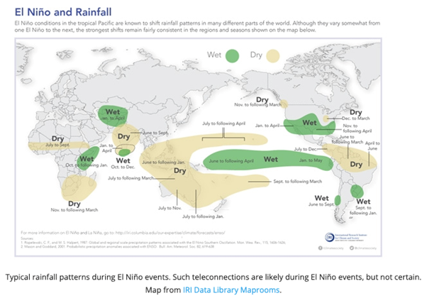
El Niño — one of the biggest variations in the Earth’s climate system significantly impacts the Indian weather. The ocean phenomenon fuels higher global temperatures and is known to weaken the monsoon, which provides over 70% of the annual rainfall over India.
The World Meteorological Organisation (WMO) has now urged countries to prepare for the El Nino, as “there is now a 60% chance that it will develop during the May-July period, rising to 70-80% during July- September period and 80% between July and September.”
While the tropical Pacific Ocean is currently in an ENSO-neutral state – near its long-term average. But oceanographers have witnessed that surface waters over the equatorial Pacific have been warming significantly since February, which was one of the hottest months on record. The strong warming near the coast of South America has been particularly “striking,” says the US-based National Oceanic and Atmospheric Administration (NOAA).
This essentially indicates that the southwest monsoon is now most likely to make its onset over the Kerala coast under the shadow of El Nino — a phenomenon that cast a negative impact on it. The update is worrying especially for large parts of Gangetic Plains where the pre-monsoon rains too have been dismal.
Normal Monsoon Despite El Nino?
While there is no one-to-one relation between the El Nino and monsoon, it is generally linked with a sub-par monsoon, and drought in several parts. One of its worst impacts was seen during the 2015 summer, when a strong El Nino reduced the seasonal rainfall to below-normal across major parts of the country.
Out of the total 15 El Nino years since 1951, nine of them led to normal to below-normal rains. Not all El Nino years bring below normal rains.
The forecast is in agreement to that of India Meteorological Department (IMD), which is also confident of an El Nino developing this monsoon season. Scientists expect that El Nino’s impact on the monsoon is most likely to be felt during the second-half. However, the IMD has stuck to its initial prediction of ‘normal monsoon’ with seasonal rainfall at least 96% of the long-period average of 87 cm.
“No two El Niño events are the same and the effects depend partly on the time of year,” said IMD Director-General M Mohapatra. The top weather scientist also believes that the negative impact of El Nino may be counterbalanced by reduced snowfall over Eurasia and positive Indian Ocean Dipole (IOD), which can strengthen the monsoon.
WMO Secretary-General Prof Petteri Taalas has, however, warned that the world should prepare for the development of an El Niño, “which will most likely lead to a new spike in global heating and increase the chance of breaking temperature records.”
At this stage there is no indication of the strength or duration of El Niño. But governments will have to watch out, as forecasts during the spring suffer from lower accuracy and can result in surprises say scientists.
Read all the Latest India News and Karnataka Elections 2023 updates here
