Dozens of towns all over the Himalayas, especially in Uttarakhand, are sitting on time bombs. Joshimath must wake up authorities.
Published Date – 12:45 AM, Sun – 22 January 23
By Nripendra Abhishek Nrip
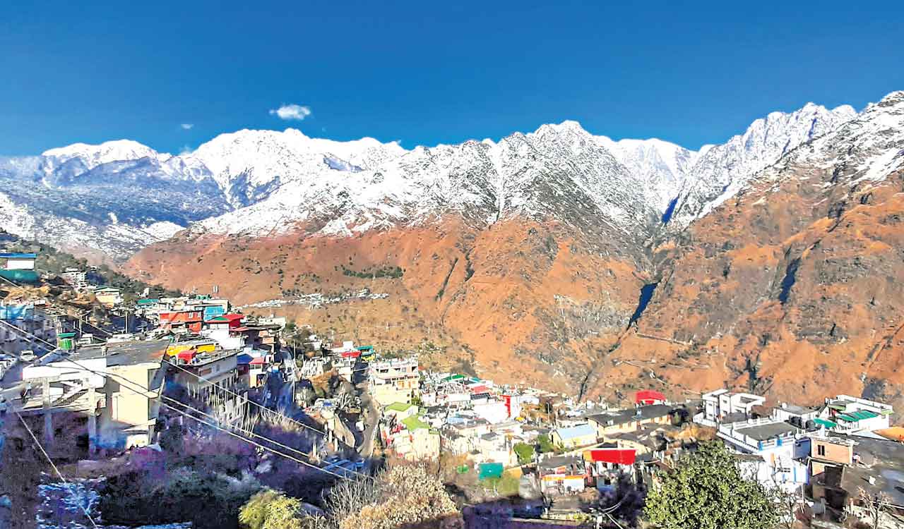
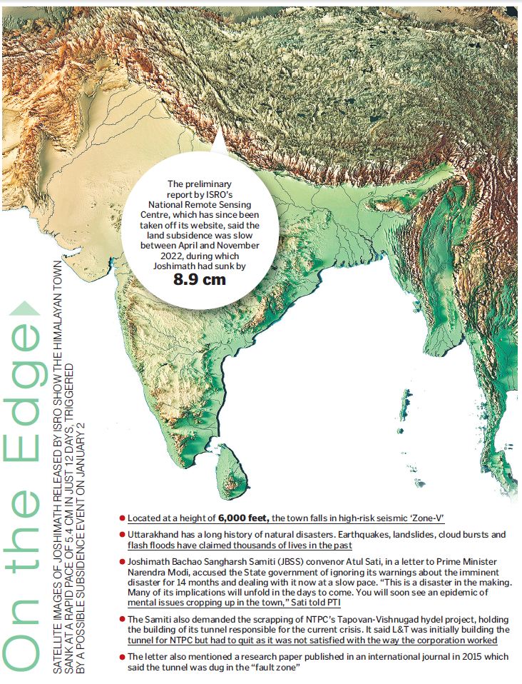
Hyderabad: Landslides, which have always been a major threat to India, are once again wreaking havoc. Joshimatha town of nearly 23,000 people in Uttarakhand’s Chamoli district, is sinking due to land subsidence. Of late, the speed of the slide has suddenly increased.
Hundreds of buildings are no longer habitable. Wide cracks have also started emerging on the ground. In some places, water is gushing out due to the bursting of the ground. Joshimath is a gateway to several Himalayan mountain climbing expeditions, trekking trails, pilgrim centres like Badrinath and Hemkund Sahib, and the Valley of Flowers, a UNESCO world heritage site. It is also strategically important as it connects with the China border.
The Problem
Lakhs of devotees throng here every year. Today this place is sinking into the pit of the earth. But this is not happening all of a sudden. It was predicted long ago but was not taken care of.
According to the 1976 Mishra Committee report, Joshimath is not situated on the main rock but on sand and stone deposits. It is situated in an ancient landslide area. The report states that erosion by river streams of Alaknanda and Dhauliganga too triggers landslides. The committee recommended a ban on heavy construction works, removal of boulders for blasting or road repair, and felling of trees.
However, construction works, hydroelectric projects and the widening of national highways have increased over the past few decades and made the region extremely unstable. Apart from this, the streams flowing from Vishnuprayag and the rock slides along with the natural streams are other reasons for landslides in the area.
Joshimath is not the only one which is on the verge of collapse. There are dozens of towns all over the Himalayas, especially in Uttarakhand, that are sitting on time bombs. The case of Uttarakhand is also special because according to geologists, Uttarakhand is the region in the entire Himalayas where earthquakes above scale eight are most likely to occur. For this reason, geologists call this area the Central Seismic Gap. It is alleged that even simple standards have not been followed in the construction of buildings here. Dehradun, Haldwani, Mussoorie, Nainital and Pauri face a similar situation.
Falling Disasters
The Himalayan region is prone to cloud bursts or landslides. The date changes, the year changes, but the incidents of rock slides and landslides do not change in the monsoon.
According to the Geological Survey of India (GSI), 4,20,000 sq km, or 12.6% of the total land area, in India is prone to landslides. This excludes snow-covered areas. Landslide-prone areas include North East Himalayas (Darjeeling and Sikkim), North West Himalayas (Uttarakhand, Himachal Pradesh and Jammu & Kashmir), Western Ghats and the Konkan hills (Tamil Nadu, Kerala, Karnataka, Goa and Maharashtra), and Eastern Ghats (Andhra Pradesh’s Aruku region).
The GSI has prepared a National Landslide Vulnerability Map on a 1:50,000 scale for 85% of the entire 4,20,000 sq km of rock-prone area in the country and work is under way to complete the rest.
Landslides are triggered by natural causes like earthquakes, heavy rains as well as some man-made constructions. Unpredictable weather, climate crisis, and heavy and intense rainfall are increasing the incidence of landslides in the country, especially in the Himalayan region.
Copying Plains
A study by the University of Sheffield found that India was one of the worst affected countries in terms of human-caused fatal landslides during the period 2004-16. The study analysed 5,031 fatal landslides from around the world of which 829 incidents from India were included. In India, 28% of the incidents of stone falls occur due to construction works.
This was also pointed out in the National Landslide Risk Management Strategy published by the National Institute of Disaster Management in September 2019. The report stated that most of the building constructions in the Himalayan region are inspired by the Delhi Master Plan, which is not suitable in the context of hill cities. Landslides often occur in mountainous areas when a large number of rocks are removed for buildings and road construction.
Deforestation is also a major reason for landslides because trees, plants, etc, keep the soil particles dense but with deforestation, the mountain slopes lose their protective layer, allowing rainwater to flow freely on these slopes. Earthquakes also cause landslides. For example, there was an earthquake in the Himalayas which destabilised the mountains, resulting in landslides every day. Due to the increasing population, a large number of houses are being built, which creates a large amount of debris that can cause landslides.
There is a danger here not only from the power projects but also from the anti-Nature development thinking. We did not learn any lesson from the unimaginable floods in 2013 in Kedarnath and again erected a heavy cement-concrete structure there. That flood cleared the entire Mandakini valley, including Kedarnath, from the human-encroached river bank area.
Again, ignoring landslide sensitivity, an 825-km road in the name of Char Dham All Weather Road is coming up. The long road network cuts through the mountains uprooting over 40,000 trees and clearing innumerable bushes, waking up old dormant landslides. On the request of Chandi Prasad Bhatt, the pioneer of the Chipko movement, a dozen expert institutes of the Government of India under the aegis of the Indian Space Research Organisation (ISRO) have identified spots vulnerable to landslides on this entire Char Dham Yatra route.
No Time to Waste
Joshimath has raised many questions. It is necessary that an independent scientific review be carried out to study the long-term effects of tunnel-based projects and new rules must be framed based on that. Projects under construction should be independently investigated along with social and environmental audits to check safety standards.
There are many measures in geotechnical engineering to prevent landslides. If we talk about roads, there are engineering structures like retaining walls, gabion walls, breast walls, wire mesh, shortcretting and slope nailing to prevent landslides on the upper and lower slopes.
And, if we talk about the mountains of Uttarakhand and Himachal, then we also need to keep in mind that when we make any structure, such as road, building, dam or tunnel, a comprehensive survey of the geological situation there needs to be done. It is very important to understand the real situation.
For example, most of the settlements on our mountains are on top of debris deposited by large landslides of the past. Humans have modified these slopes to make them suitable for farming to increase their livelihood. But then, the environment at that time was different. It rained very little then. The atmospheric temperature was low, due to which the debris stuck on the mountain slopes and remained stagnant. Today, the same debris is sliding down in the form of landslides due to rising temperatures and heavy rains.
The country should identify the sensitive areas and action should be taken in this regard on priority. Hazard mapping can be done to identify areas prone to landslides. Along with this, more attention must be paid to plantation programmes to prevent landslides. It is the duty of the government to ensure insurance facilities for the people to deal with the loss so that they can be rehabilitated.
The way Joshimath, a cultural heritage, is getting absorbed in the cheek of time, must ring alarm bells in government corridors. The government will have to take concrete steps while there is still time.
(The author is a researcher from Saran, Bihar)